
First off, this post has nothing to do with 5G. Actually, the one thing wireless communications related I will put up front. I had LTE service pretty much the entire way to the summit of the Grand Teton…
Background on the annual Mountain Trip
My buddy Ben was my room mate in the Army from 2014 until I got out in 2015. We kept in touch more than I did with most of my Army friends. During Covid, he went on a road trip before starting Med School in Wisconsin. He stopped by my house in Denver for a few days, and we hiked up ~14,200′ Mount Princeton outside of Buena Vista, Colorado.


After that, we planned a subsequent back packing trip in May of 2021. My ambitions were too high for how early in the season it was in Colorado, as I had planned for us to do the Four Pass Loop in the Aspen/Snowmass Wilderness. We camped at the Snowmass trailhead and hit the trail heading for 14,105′ Snowmass Mountain early the next morning with the intent to camp at Snowmass Lake and head for the summit the following morning…


Everything started off how we had imagined.The approach to Snowmass lake is long, but the elevation gain is gradual (When I went back a year after this trip, it was about 10 miles to reach Snowmass Lake with 2,775 feet of elevation gain.) Once we got to the home stretch leading to Snowmass Lake around 10,500′, we started to encounter snow on the trail which was softened by the mid day sun. He began the grueling task of walk, sink, walk, sink, walk, sink… also known as Post Holing…

With our camp packs weighing in somewhere around 50 lbs each, we decided that this may have been overly ambitious of us to take on the Four Pass loop in early season. Another month and most of the snow would be gone, unfortunately, May was the only time both of our schedules had allowed us to plan this years trip. So we retreated back to my truck, headed back towards Frisco, CO where we grabbed a beer at Outer Range, and contemplated our next moves. The trip wasn’t over, but our plan had disintegrated.
We decided to camp at one of my favorite drive by sight seeing spots, Clinton Gulch, nestled between Copper Mountain and Leadville, CO. We spent a pretty cold night at camp around 11,000′ and woke up the next morning and decided to go for the tallest mountain in Colorado, Mt. Elbert. This seemed like a good idea given the amount of snow, and the normally easy slopes of Mt. Elbert should provide easy passage to a couple of overly enthused amateur hikers.


My premonition that this would be our best bet to reach a summit given our experience in early spring hiking proved to be correct. Though we still encounter snow on the trail, the going was easy(ish) since we could dump our heavy packs in my truck and just take essentials to the summit.
Our trip time was winding down, and our options to hike and climb were limited. We got back to my truck and headed for another one of my favorite camping spots near the Missouri Gulch trailhead. We would hike the steep slopes into Missouri Gulch the next morning to attempt Missouri Mountain, another generally “easy” trail given the proper conditions.


There was plenty of snow on the trail, but again, we were lighter and moving faster in the cold morning which kept the snow mostly solid beneath our feet. We reached the Northwest Ridge trail junction at about 11:00 AM, the sun was high and the snow started to soften. After a rocky outcrop, we reached an obstacle… About a 150′ stretch of soft snow on a steep bank. We weighed out our options, and decided it was best to turn back. The views on the hike satiated our wanderlust, the trip had come to an end. Not exactly what we had hoped for, but any time spent outdoors is never time wasted.
Grand Teton trip planning
A couple of years passed and Ben and I kept in contact. In 2023 I began to flirt with the idea of doing the Grand Traverse of the Teton Range. I reached out to a guide company, and got little response back. I didn’t have the bandwidth to nag someone over e-mail at the time, and the trip fell through the cracks. In the late summer/early fall of 2024, Ben got married in Western North Carolina. My wife and I traveled up following the wake of Hurricane Helene. The story of Ben’s wedding is a story in itself, but the bottom line is that we reunited and started talking about the mountains again. In January Ben was antsy (and probably a little more assertive and focused than I was at the time) to get a trip booked. He communicated with Jackson Hole Mountain Guides and got us setup for a guided trip to summit the Grand Teton in early August. It would be me, Ben, a his father Rob. Time to start training… In March.

Honestly, I had little time to think about the trip until the two weeks leading up to August. I didn’t even book my flight until July, and luckily Ben handled most of the other logistics of where we were camping, etc. My train of thought was that as long as I had my tent and sleeping bag, I could always find a place to sleep. As for my training, Florida isn’t exactly a mountain training ground, but as I learned. The summer heat and humidity is a tool for suffering. I started running 4 or 5 days a week and supplemented with strength training one day a week, mostly focusing on single leg, posterior, and core strength. Deadlifts, Bulgarian Split squats, box step ups, renegade rows, etc. My runs would mostly be easy miles to build endurance between 5 and 10 miles, with one or two days a week dedicated to speed work of 400m, 800m, or 1600m intervals and tempo runs. I averaged between 20 to 30 miles a week and was doing a majority of my running during the heat of the day… It was miserable, but effective.


Next was packing for the trip. Luckily, I have accumulated most of the required gear over the years, and I am also infamously an over packer.

Camping Needs
Since we would be camping on our own for the first two nights
- Tent (Marmot Limelight 2 Person)
- Tent Spikes
- Spike Hammer
- Sleeping Bag (Big Agnes Torchlight 20)
- Sleeping Mat
- Inflatable Camp Pillow
- Hiking Pack (Osprey Aether 55 Liter)
- Camp Stove (Jetboil)
- Gas
- Camp Meals
- Plates and Spoons
- Steel Cup
- Compression/Water Proof bags
- for packing clothes
- Tent Storage
- Sleeping Bag Storage
- Trowel
- Towel
- Power Bank
- Clothes for however many days
- Swim shorts
- Toiletries
Teton Climb Needs
The guided trip to the summit of the Grand Teton is three days, where JHMG provides tents and meals at Corbet High Camp at 11,000′
- Tent, Sleeping Bag, Sleeping Mat (Provided by JHMG)
- Helmet & Climbing Harness (Provided by JHMG)
- Approach Shoes (Scarpa – for rent by JHMG)
- Rain Jacket
- Mid Weight “Puffy” Jacket
- Water Filter/Purification (Grayl UltraPress)
- Medical Kit
- Socks (3 Pairs)
- Hiking Pants
- Headlamp with Fresh Batteries (Black Diamond Spot 400)
- Spare Batteries
- Hiking Poles (Optional)
- I’ve found these save my legs and help me regulate my heart rate
- Snacks for hike in, summit day, hike out, and hanging out at camp
- Wag Bags (JHMG provided)
- Baby Wipes
- Camp Pillow (I didn’t bring mine…. big mistake)
- Water Source (I brought two, only one is required, minimum 1.5 L)
- 1.5 L Camel Back
- 1.5 L Water Bottle
- Chapstick/Lip Balm (I didn’t bring any…. another big mistake)
- Sun screen
- Hat
- Sunglasses
- Gloves
- Close Toed Camp Shoes (optional)
- Synthetic Sun shirts with Hood (Patagonia Capilene)
- These are life savers!
Trip Itinerary
Day 1: Arrive to Jackson Hole, Camp at Jenny Lake
Day 2: Meet JHMG Guide, Training Climb at local crag, Gear check with guide, Camp at Lizard Creek Campground
Day 3: Meet at Lupine Meadows Trailhead, Hike into Corbet High Camp, refine plan for summit day plan, Camp at High Camp
Day 4: Early wake up, attempt to climb to summit of Grand Teton, Camp at High Camp
Day 5: Hike from Camp back to Trailhead, or a weather day if previous day summit attempt is cancelled.
Day 6: Fly back home
Day 1: Arrival
I opted for an early arrival time into Jackson Hole so I could begin acclimating, grab some essentials, and get a lay of the land. My turbulent flight arrived into JAC airport around 12:50. I was greeted with my first sight of the Grand Teton’s as we began our descent, and again as I stepped off the plane. I was in awe, and immediately felt at ease being back in the mountains.


I headed into Jackson Hole and did some sight seeing, picked up a new sleeping pad, gas for my camp stove, and some food for camp. Ben and his dad would not arrive until later that evening, so I decided to kill some time by heading into Grand Teton National Park to get a better view of our route, and check into our camp site at Jenny Lake.


I was greeted by a wonderful couple at the Jenny Lake campground who gave me a great briefing about the site and surrounding area, with a big emphasis on the Bear problem in the area. SPOLER ALERT: I didn’t see any bears on this trip… I settled into the camp site, set up my tent, had a beer, and decided to stretch my legs out. I took a brisk 3 mile “hike” on the well traveled Jenny Lake trail where I saw a handful of deer and a lot of tourists. I wish I had more time to explore the area and the trails, but look forward to possibly bringing my kids to this place in years to come.


It was getting later in the evening and I needed to head to the airport to meet up with Ben and his dad when they landed. I stopped at a pull off and admired the Teton’s during a short rain storm, then proceeded to the Airport. After exchanging hugs and greetings, the three of us headed back to the camp site and settled in for the (cold) night. We all noticed how quiet our first two nights of camping were. No wind, no animals, nothing. It was eerie but also peaceful and comforting.
Day 2: Training
Ben and his dad woke up early and went for a cold plunge into Jenny Lake. I slept in since I did not hear anyone stirring around camp. I crawled out of my tent, and we all began to break down camp since we would have to move to another site that evening. We packed all of our gear into the rental car and headed south towards Jackson Hole to grab breakfast, then to Black Diamond to meet with our guide.
We grabbed some “Meat Burritos”, coffee, and water at a local market where we were greeted by a Doe and two baby deer. Surely this was a good omen for the rest of our trip.

We arrived at Black Diamond and met Curtis in the parking lot. Curtis is either a guide himself or one of the high camp staff that works for JHMG. He ushered us into the store to meet with our Summit Champion Nate “Married to the Rock” Opp. We did a quick introduction with Nate, and he assessed the shoes we were currently wearing (we all had various hiking shoes on) and he decided that renting approach shoes for the training and summit days would be necessary. I have always generally worn the same shoes on most of my mountain adventures and had never worn traditional approach shoes, but as soon as I put them on, I regretted never doing so before. The grip of the rubber on the approach shoes was immediately apparent. Nate also handed out Climbing harnesses and Helmets to those that needed them for the training that day.
Nate briefed us on the rest of the day, gave us the destination for our training and we headed to Curtis Canyon on the National Elk Refuge. During the drive we talked about how immediately happy we all were with out guide, Nate is the definition of a climber and a man who has a deep passion and respect for the outdoors, but also has an immediate humor in his actions and words.
At the Trailhead we gathered all the required equipment, water, and snacks and took a brief hike into the crag where we passed numerous skeletal Elk remains. We donned our helmets and harnesses and Nate got to work with us. First we went over the commands of climbing, such as “On Belay”, “Belay On”, “Climbing”, etc. Then we went right to work. Ben belayed Nate up a 20-30 foot pitch, where he then belayed each on of us to his position one by one. From there, Nate went to the top of the crag another 30 to 40 feet above the initial pitch. This pitch was a bit more difficult than the first, with a lot of smooth features that required attention to detail to find proper hand and foot holds, as well as a bit of brute force.
Once we all arrived at the top of the crag, we received of first of many “Awesome Job, guys” from Nate. This and “Bueno, man” became the Nate-ism’s we began to anticipate and celebrate whenever they became heard. Next, Nate setup a rappel station for us to get back to the bottom of the crag. One by one, we leaned out over the edge of the rock with our rope as our break in one hand, and did our best to not “fight gravity” and follow the rope to the bottom. Ultimately, rappelling is what rattles my nerves the most, but is one of the most radical things to do on a mountain.
The last part of our training was a top rope pitch where we each took a turn belaying the climber on the pitch, when reaching the top the person belaying would aid in the rappel of the climber. We all did our turns on the pitch and helped each other tie in, with Nates inspection and approval. Nate made it a point not to over load us with information, and give us all practical hands on scenarios to test our skills. We all felt comfortable and confident at the end of the training session.


After climbing, we headed back to the store to link back up with Nate to give us our equipment inspection. Not quite like an Army packing list inspection, Nate really only wanted to see items he deemed necessary for the trip and advised us to leave as much as possible at the trailhead the next day so that we would hike to camp “as close to naked as possible.” We set a time to meet Nate the next morning at the Lupine Meadows trailhead at 8:30 AM, and departed. We grabbed lunch at Snake River Brewing, grabbed some additional essentials and started north to Lizard Creek campground.


Lizard Creek campground was a bit less formal with their check in process, though the actual camp site was much larger and accommodating than our previous site at Jenny Lake. We set up our tents, snacked, and decided to head down to Jackson Lake to wash off the days of sweat we had accumulated, but not before getting stung by a yellow jacket. Those things hurt.


Back at the campsite, I conducted my favorite camp activity. Gathering firewood. We made a fire, Rob hit the sack early, Ben and I stayed up for another hour or two to snack and talk shop, then we retired around 9:40 PM. Tomorrow would be the most physically demanding day of the trip and the start of what we came here to do.
Day 3: Corbet High Camp

We packed up camp, headed to Jenny Lake to get some last minute supplies and food, then parked at the Lupine Meadows TH where Nate was waiting for us. He gave us a bag to disperse between the three of us that included food and wag bags for the next three days at camp. We did some last minute organizing, strapped our packs on and started up the trail. The first 2 to 3 miles is pretty mellow, mostly in the shade of trees, where the biggest obstacle is the number of hikers on the trail. After getting mostly above tree line, you arrive at the meadows where the herds start to thin out, though there is still no shortage of hikers, campers, runners, and so on.
Right before the meadows, you emerge out of the trees and round a corner where you get your first sight of the Tetons with Middle Teton looming over the valley directly in front of you. Middle Teton has what I think is one of the more unique features I have ever seen on a mountain. What looks like a straight vertical crack up the center is actual referred to as the “Black Dike” which is a “dark intrusion of igneous rock” which is also known as diabase.
Sidenote: I wish I knew more about geology, since I am fascinated by rocks. Maybe Nuradio Concepts will turn into a rock blog in the future?


Nate and I kept each other entertained for a good amount of the hike mostly talking about Metallica. Our favorite songs, the members of the band, and so on. For days after the trip I started comparing my “off the top of my head” list with my actual favorite Metallica songs list. I completely spaced out on Battery and Blackened for some reason… Must have been the altitude. So without further adieu, and to break up the trip report, my top 10 Metallica songs mostly in order.
- 10: Motorbreath
- 9: The Unforgiven
- 8: Escape
- 7: Nothing Else Matters
- 6: Turn the Page
- 5: Orion
- 4: Fade to Black
- 3: Battery
- 2: Blackened
- 1: … And Justice for All
At the meadows we took a lunch break. Italian Sandwich from Dornan’s grocery store. From here we took a right and headed up switch backs skirting the right side of a waterfall. Once at the top of the waterfall, we entered the alpine zone where greenery subsides to scree, boulders, and granite slabs.


After some modest elevation gain, we took another quick break to catch our breath before our final ascent into basecamp. At this point we were just below 10,000′ with another 1,000 feet of gain in roughly a mile to reach Corbet High Camp. We set out for our final push to camp, with Nate—who has been guiding for 20 years—leading the way. I have to say, he truly knows how to set a sustainable pace. That’s one of my biggest takeaways from this trip. In the past, I’ve usually burned myself out by charging ahead at whatever speed gets me there fastest, only stopping when I need a break. This time was different. After spending nearly three years at sea level, I was worried about how I’d handle the altitude. But I think the two main reasons I felt so good were:
- My training in Florida’s heat and humidity.
2. Nate’s steady, deliberate pace.
We carried on uphill knowing our destination wasn’t much further. Drill Sergeant Nate came out as he calmly asserted “Just keep moving, don’t stop, it’s harder to start again after you stop.” I didn’t feel bad, but I kept looking up and I thought I saw a tent about 100 meters away, but also though the sun might have been getting to me. Turns out it was the top of one of the sleeping tents perched on the edge of camp, so it was nice to finally see our days objective.
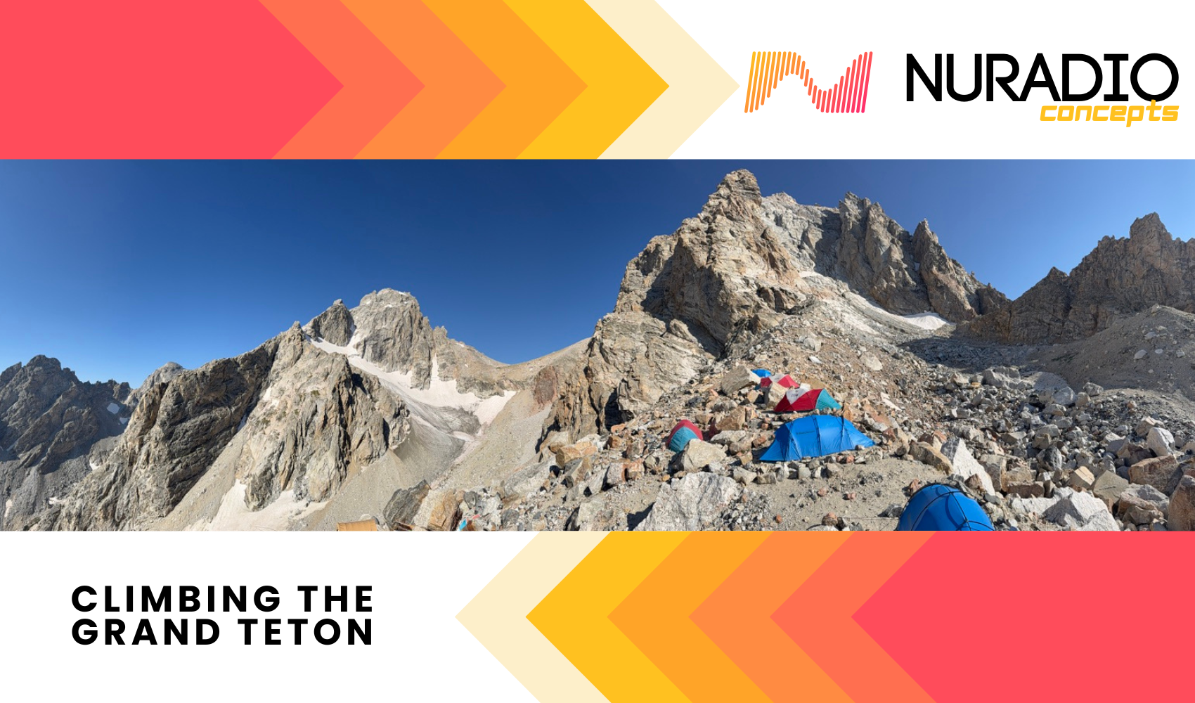
We turned a corner and came face to face with the Middle Teton Glacier, the Lower Saddle, Teepe Pillar, and the Grand Teton summit. These would be our views from camp for the next two days and nights. I immediately felt like I didn’t want to leave.

We were the last of four parties to arrive at camp that day. I believe 16 people in total would be staying the night to include guides, patrons, and camp staff.
- One lady was climbing 1:1 on the Upper Exum with her guide
- A family from Connecticut: Mother, father, and two teenage sons
- Three friends from Michigan who take yearly climbing trips together


We dropped our packs and Nate gave us the tour of Corbet High Camp to include “The Pee Rock” being the marker for where you should go beyond if you need to relieve yourself, the toilet and use of wag bags, and the tents we would be sleeping in. Ben and I in one tent, Robbie in another tent. He then distributed our helmets and harnesses and told us that we would meet again around 6 PM for dinner and to receive the plan for the next morning.
The three of us relaxed for awhile, sitting in the sun and talking. Robbie decided he would lay down, while I headed to a rock to sit and admire for awhile, Ben joined me. Soon Nate walked by and disappeared below the ridge line we were sitting on. Ben and I joked that soon we would probably see Nate climbing the east face of the Grand or something crazy…. Not much longer after that comment, Nate appeared, climbing a nearby cliff that plateaued just west of our camp. This would be a common theme with Nate, like playing “Where’s Waldo”, it was like “Where’s Nate and what is he climbing” while we were at camp. Truly a man of the mountains.
Ben and I decided to take the easier route to the peak of the cliff where a large teetering boulder sat perched on the cliffside and a unique block thrusting out from the cliffs edge. There is a short path that took us maybe 10 minutes to reach the top. A narrow ridge linked the plateau to the peak of the cliff with dramatic exposure on both sides.


With time to kill, I observed other hikers in the valley below to figure out what our likely path would be the next morning. I knew a few details about the route ahead, but as this was a guided trip, you become less intimately familiar with land marks and routes than you normally would be. I could see hikers making there way through the moraines below to a cliff just left of the red headwall we could see below the lower saddle. The cliffs have fixed ropes in place to aid climbers access the switch backs to the lower saddle. This would be our first bit of “technical” climbing in the morning, as our guides would put us on ropes for the section.

I started to take closer looks as some of the features in the area as well. Notable was the Middle Teton Glacier and the crevasses and serac like overhangs on the northeast flank of the mountain. I was able to get closer looks at these features the next day.

We met up promptly around 5:30 PM where Nate handed us a plate of cheese, salami, and crackers to enjoy before dinner. We ate Sweet and Sour chicken and rice, and Nate gave us the plan for summit day.
- 4 AM Wake up, 5 AM departure
- It would be windy and cold, wear appropriate clothing
- Another guide would be making his way to camp tonight to roll out with us in the AM to give a better ratio of guides to climbers
- Come down to kitchen tent at 4:15 for coffee, breakfast, wear your harness, helmet, head lamp, approach shoes, and be ready to step off at 5 AM
We headed to our tent and attempted to sleep with thoughts of wind, cold, exposure, and more in our minds. It was windy that night, and if you’ve never slept in a tent in the wind, just know a small breeze sounds like a storm force wind. Also, I did not bring my camp pillow. Who needs sleep?
Day 4: Summit Day


Surprisingly the first two nights camping at the camp grounds were much colder than the night at high camp. Maybe the tents were that much better than mine? I emerged from my tent with Gloves, a T-Shirt, long sleeve sun shirt, puffy jacket, rain jacket and pants (no long johns, generally my legs don’t get as cold as my upper body does.) Two cups of coffee and a microwave burrito later, I was getting ready under a red lens. It was vaguely reminiscent of my time in Afghanistan getting ready for a night mission. The stars were out, it appeared to be clear, though windy, and I only remember one point that entire day that I felt cold. In the calamity of getting ready in the dark Nate said “There’s our starlink” as I looked up and saw the constellation float through the sky. It felt a bit intrusive, seeing this technology float by as were supposed to be in nature, on a mountain, detached from the world. That, and the LTE service we had the entire time…


Our new guide Ben Wu joined us, and Nate and Ben talked tactics since this would be there first time team guiding together. We double checked ourselves, and it was 5 AM. Time to step off. We descended down into the moraines below us, fortunately having the later step off time means less time under the light of a head lamp. About 45 minutes into our walk, I turned mine off and let the morning light lead the way.


Not even an hour into our walk we reached the base of the cliffs. Guide Ben took out his rope and ascended to the top so that he could setup a belay for us. With the fixed ropes or without, the ascent of the cliffs is mostly a class 4 scramble, though understanding the position the guides are in, they will always lean towards risk mitigation since they do not know each climbers skills, abilities, strengths, and weaknesses. The ropes are more helpful for the down climb than the ascent, as is with most class 4 down climbs, they can be sketchy and turning your body inward towards the rocks you are scaling is usually the safest way to navigate these.
Once at the top of the cliffs, a few switch backs and you are on the lower saddle where you start heading North/Northeast towards the Grand Teton. This is also where you catch the first glimpse of the route and terrain ahead.


Our next destination is to head towards the Grand, where there is a distinct group of black rocks at the apex of the lower saddle. This was our first break of the morning, which marks the start of the “fun part of the Grand ascent.”


As I mentioned previously, being guided causes you to lose track of where you are in terms of land marks, names of moves, etc. So from here on might be a whirlwind. Ben and Nate’s experience really shined here as they were deploying and stowing rope constantly in various fashions. Sometimes Ben and I would go with one guide, while Robbie would go with the other, then we would all link up. We would catch up to the team in front of us and as they ascended the next pitch, we would be ascending the previous pitch and the guides all jumped in to aid everyone. It was truly impressive, though some times chaotic to hear “On belay!” or “That’s me!” from other teams nearby while you’re in the middle of a pitch.
After a bit of scrambling we arrived at a plateau where I could see climbers up on a cat walk to our right facing the upper saddle. I didn’t know it at the time, but I was also looking at the rappel we would take on the way back down. At the base of the rappel is the cat walk, which I believe we took and is where the 5.8 Pownall-Gilkey pitch is.


More scrambling, more climbing, this is a part that is a little fuzzy to me but looking back at my photos, we appear to make it up to the cat walk, get tied into to a traversing rope on a ledge, where we get to the Pownall-Gilkey pitch directly after.


The P-G pitches weren’t very difficult, mostly thanks to slings that are in place on the route. Nate told us to “get aggressive” here and you should have no problems. Mission accomplished.
After all of that, Ben roped Ben and I together and we “short-roped” to the summit. Robbie went ahead of us with Nate. This part was pretty fun, mostly class 3 scrambling, where again, the guides need to be risk adverse. We ran into a few parties coming down off of the summit and caused a bit of a bottle neck at points, hindering our progress. I think this was the point where I started to feel cold, after the climbing and going, and then suddenly stopping and waiting. Most of the climb is in the shade too, but the wind was not really a factor once we got off of the lower saddle. We started moving again, and before we knew it we were on the summit of the Grand Teton.

We spent 10 or 15 minutes at the summit. There was one other party up there with us from JHMG. So we got to take it in with a relatively small crowd.


At this point, you’re only half way. As they say “making it to the top is optional, getting back down in mandatory.” So we started to head down. The next thing I remember is getting to the belay station. Nate and Ben came up with a plan, Nate walked to the ledge and yelled “Rope!” as he tossed our rappel line down. Ben got to setting up the belay station at the top. Nate descended the rappel, and Ben called us over one by one to scale the cliff. There was a pile of lose rocks (baseball/softball size) next to the belay station to which point Ben sternly pointed out “Watch these rocks, Nate is at the bottom of this!” which really emphasized the importance of situational awareness and safety in those situations.

The rappel was my favorite part of the day, coming from someone who hasn’t done any roped climbing in the mountains previously. You start leaning out over the ledge, where you can walk yourself backwards and down a bit before you go entirely over the cliff where you can still use your feet a bit before you descend an over hang and then if you want to, you can rappel most of the rest of the way down hanging on the rope. At the bottom of the rappel, Nate took me off the rappel line and instructed me to go behind a large rock where Robbie was about 30 feet away. I suppose this was to shelter us from any rock fall that might happen. I did not envy Nate in that position, looking up, hoping he doesn’t see one of those baseball size rocks coming down the cliff.

Once the team was assembled, we started scrambling down the cliffs. I think Guide Ben broke off from us around this time as he was not really needed anymore. There were a couple of parties descending with us, so we made sure to be aware of foot and hand placement on any rocks that might become projectiles. Nate tied the three of us together and we want through the “Eye of the Needle” which is a small enclosed rock cave that you can enter and exit.


Not too much further down and we were back on the lower saddle. Some more switch backs, and a quick stop to get some fresh water and then we arrived back at the cliffs for our final rappel of the day.

A quick uphill stroll back to High Camp and a celebratory “Awesome job, guys” from Nate. I admired more of the Glacier since we were up close and it was now day light. I really wished I had brought some summit beers, but that would have to wait until we got back to the car the next afternoon.

We retreated to our tents for a little siesta, though the mid day sun baked the tents, and opening the air vents made the rattle of the wind that much more intense. I laid for about 30 minutes, looking backward out of the tent to see the summit we had been on a few hours prior. I thought about what trips I would take next possibly, but I can certainly say that I will be back in the Tetons soon.

There’s not much else to this story except us seeing Nate hanging over some boulders and figuring out new problems, while everyone else slept or rested. I admired him for his dedication and passion for climbing and the life of a guide.

We ate dinner, chatted with the other parties, made a plan for the next day where Ben would do some climbing at High Camp with Nate, and then we would head back down to the trailhead. A little after 11 AM the next morning we started walking and 2.5 hours later we were at the trailhead. Honestly, the easiest part physically, but never easy to leave the mountains.


Additional Information
Leave No Trace : Using the power of science, education and stewardship, the Leave No Trace organization is on a mission to ensure a sustainable future for the outdoors and the planet.
Recreation.gov (Campsite reservations and more)
Pownall-Gilkey Route (Mountain Project)

Leave a Reply